Skip to content
Doug Maready, MD
Lifestyle Environment

← All topics

Lifestyle & Environment

How Walkable Is Your City?

Three trips, three cities, three walks. A doctor's-eye field report on whether American cities are designed to move you — or move past you.

DM
Field notes from Doug Maready, MD
Doctor Doug Content Library · Spring 2026
By the numbers
3 mi
Distance from my San Diego hotel to the airport. I walked. Saved $30. Caught my flight. The bike lockers at the terminal were full.
Field notes, San Diego, April 2026
Field Report

Three cities, three walks, three verdicts.

I travel a lot for medical work. At some point I started using my hotel-to-meeting walks as a referendum on the city itself: do the sidewalks connect, do the lights cooperate, do the businesses open onto the street, do other people walk too? Here's how three places I visited this year graded out.

A · Built for it San Diego, CA · April 2026

The airport that put a walking path inside the terminal.

The plan was to take a rideshare from the Manchester Grand Hyatt to San Diego International. Three miles. Thirty bucks. I checked the weather, looked at the harbor, and decided to walk it instead.

The Embarcadero trail runs almost the entire way. It's wide, flat, and loud in the best way — sea lions barking, halyards clinking, families on rented bikes weaving past you. You pass the USS Midway, the seaport village, the cruise terminal. By the time you get to the airport, you've walked through what feels like an entire downtown's worth of good urbanism before you ever see a baggage claim sign.

Then SAN does something most American airports don't: it has a designated walking and bike path right into the terminal. Public art along the way. Wayfinding signs that assume you're a pedestrian, not a confused driver. It is, I want to stress, an airport.

When I got to the curb, I noticed something I hadn't expected: the bike racks and lockers were packed. Not "a bike or two leaning against a fence." Packed. Full lockers, every rack used. People were commuting to the airport on two wheels.

That's not an accident. You don't get full bike lockers because cyclists are scrappy. You get full bike lockers because somebody made the call, years ago, to spend money on infrastructure that invites people to move. Shout-out to whoever ran that meeting.

When you make the active choice the easy choice, people take it.

I've now walked from a hotel to an airport in seven cities. San Diego is the only one where I genuinely felt the city was on my side the whole way.

Embarcadero waterfront, San Diego
The Embarcadero — flat, wide, harbor on one side, downtown on the other.
Hyatt to SAN walking route map
The route: Hyatt to SAN, about 3 miles, mostly along water.
What worked
  • Continuous waterfront path — almost zero road crossings
  • Pedestrian-grade signage inside the airport approach
  • Full bike lockers at the terminal — proof of demand
  • Public art and harbor views built into the route
Caveats
  • Last quarter-mile is busier (hotel shuttles, taxi queue)
  • Bring a real bag — TSA still expects you
  • Summer afternoons get hot; morning flights win
B+ · Surprised me Indianapolis, IN · February 2026

I expected a parking-lot maze. I got a Midwestern mini-DC.

I was in Indianapolis in February. The Indianapolis Marriott Downtown is on West Maryland Street, about a block from the convention center. I had a free morning, the temperature had clawed back up to "tolerable Midwestern winter," and I needed breakfast. Patachou — a local cafe a coworker swore by — was only a 0.2-mile round trip. I walked it.

Later that day, I ventured across town to visit a gift shop and came across the Soldiers' & Sailors' Monument — a 285-foot limestone obelisk in the middle of a roundabout. It works like a downtown compass: you can be five blocks away in any direction and still know exactly where you are.

The walk over was cool. The sidewalks were continuous. The crosswalks gave you enough time. Office workers and students moved past with their Hoosier sweatshirts on, eyes down, making good time.

Patachou calls itself "a student union for adults," which is somewhere between a tagline and a confession. I had a green omelet, a slice of avocado, sourdough toast, arugula — earned, even on a short walk.

In a walkable city, exercise stops feeling like exercise. It just feels like getting on with your day.

Welcome to Indianapolis sign at the airport
Stepping off the plane. The "Welcome to Indianapolis" neon sets the tone.
Indiana Statehouse with INDIANA THE BOLD billboard
The Indiana Statehouse. The "INDIANA THE BOLD" sign is doing a lot of work.
View down a brick street toward Soldiers and Sailors Monument
Monument Circle as compass. You orient by it from blocks away.
Soldiers and Sailors Monument up close
The Soldiers' & Sailors' Monument — 285 feet of limestone where four streets meet.
Green omelet, sourdough toast, salad and avocado at Patachou
Patachou: green omelet, avocado, arugula, sourdough. Earned.
What worked
  • Diagonal avenue pattern + central monument = effortless wayfinding
  • Sidewalks plowed and salted by 7 a.m.
  • Real food a quick walk from any downtown hotel
  • Brick streets force cars to slow down
Caveats
  • Cross an interstate and the friendly grid disappears
  • February will test you; layer up
  • Wind tunnels between tall buildings are real
B · A walkable pocket inside a stroad city Tempe, AZ · Year-round

One great path is enough to change the math for thousands of people.

I live in metro Phoenix, which means most of the Valley grades out somewhere between "you might survive crossing this six-lane stroad" and "no." Tempe is the exception, and the exception is almost entirely thanks to one piece of infrastructure: the Rio Salado Pathway along Tempe Town Lake.

The lake itself is a feat — they dammed a section of the Salt River bed in the late '90s and produced a two-mile body of water in the middle of the desert. The path along it is paved, flat, and continuous. It connects ASU's campus, Tempe Marketplace, Mill Avenue, the Tempe Center for the Arts, and a half-dozen apartment complexes that lined up to be there for a reason.

I've used this path with my kids a lot. One day on motorized scooters; bikes on several other occasions, including a stretch where we rode the river pathway all the way down to the airport. On my own, I've walked from the Mill Avenue Bridge across to the Tempe Town Lake Pedestrian Bridge more times than I can count — a few of those were walking events I either organized or joined.

On any given evening you'll see everything: rowing, sailing, biking, rollerblading, scootering, jogging, walking, and people just sitting around relaxing. Step off the corridor and the spell breaks fast — but that's the point. You don't need a whole walkable city to change a person's habits. You need one walkable corridor that connects the things they actually do.

A single great path can be the difference between a sedentary week and an active one. That's not metaphor; that's the data.

If you live within a ten-minute walk of Tempe Town Lake, your odds of meeting weekly physical activity guidelines go up — quietly, by default, without any New Year's resolution. That's the whole game.

Doug and family on the Tempe Town Lake Pedestrian Bridge with electric scooters
Tempe Town Lake Pedestrian Bridge with the kids — scooter day.
Doug and family at Tempe Town Lake with sailboats in the background
Lake-side, sailboats out — a typical evening on the Rio Salado.
Doug and son in a tree at a park along the Rio Salado pathway
Off the path: parks, trees, and the small detours that make a corridor work.
What works
  • One continuous, car-free corridor through dense activity centers
  • Lake views, public art, restrooms, water fountains — actual amenities
  • Connects three of the area's biggest pedestrian draws
  • Functions year-round (with sunscreen and an early start in summer)
Caveats
  • Step off the corridor and Tempe is car-default again
  • Summer afternoons are genuinely dangerous (115°F is not a joke)
  • One corridor isn't a network — most of the Valley still grades poorly
The Science Behind the Verdicts

Why your built environment is a clinical issue.

If you treat any chronic disease that responds to physical activity — and almost all of them do — your patient's address matters. Click any card for the data.

01

What "walkable" means

Five measurable dimensions: density, mixed use, intersections, sidewalks, and transit. Walk Score is a useful proxy.

See pearls
02

Walkability is a vital sign

Living in a walkable neighborhood is associated with more weekly activity, lower BMI, and lower CV risk — independent of income.

See pearls
03

The 15-minute city

The urbanist concept that became a public-health concept: most daily needs reachable on foot in 15 minutes or less.

See pearls
04

What clinicians can do

Rx-level interventions, advocacy moves, and how to talk to patients about an environment they didn't choose.

See pearls
Try It Yourself

Score your own city in 60 seconds.

Five questions. The same rubric I used to grade these three. Whatever you score, the next step is the same: walk a little more in the spots that work, and pay attention to the ones that don't.

The 5-question walkability scorecard

Sidewalks, intersections, mixed use, transit, and the "would I let my kid bike here" test. Click each step to expand the rationale.

Open scorecard
+49

Additional minutes of weekly physical activity associated with high-walkability neighborhoods vs. low-walkability ones (Sallis et al., IPEN study).

Field Notes & Sources

Field reporting: Doug Maready, MD. San Diego (Manchester Grand Hyatt → SAN, April 2026). Indianapolis (Marriott Downtown → Patachou, February 2026). Tempe (Rio Salado Pathway, ongoing).

Methods note: "Walks" measured by phone; verdicts are based on the author's clinical perspective as an obesity-medicine physician and on the published literature cited in each card. This is editorial commentary, not a peer-reviewed walkability index. The field-report grades are the author's own.

Why this is in the Content Library: Built environment is a determinant of physical activity, and physical activity is a determinant of nearly every chronic disease I treat. Patients don't choose their cities the way they choose their diets, but where they live shapes how they move. That belongs in the conversation.

Walkability / Score Your City
Try It Yourself

Score your city in 60 seconds.

Five questions. Each one yes/no/sort-of. No spreadsheet, no app. Walk five blocks from your front door (or your hotel) and answer honestly.

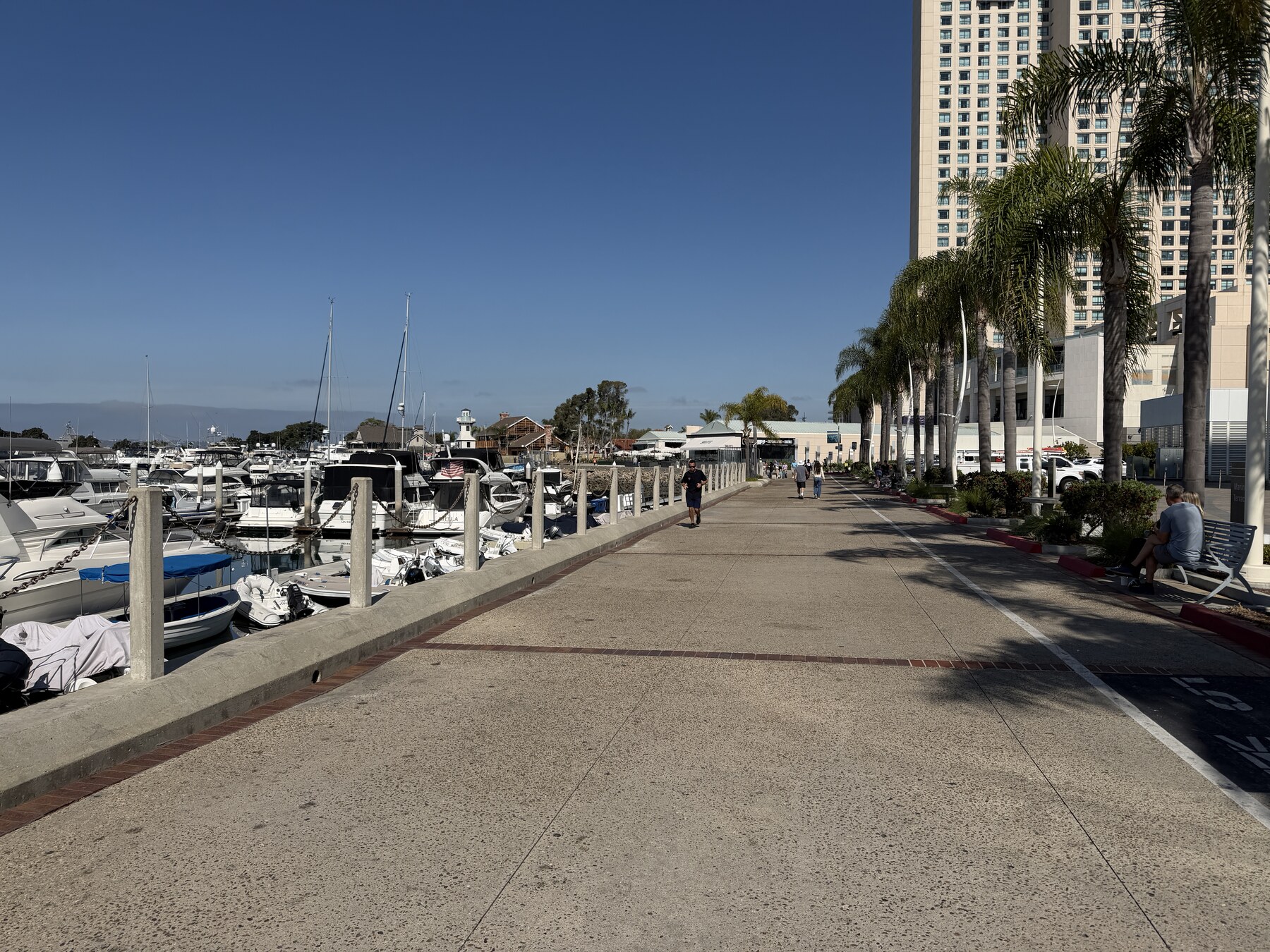
01Are there sidewalks the whole way?

+

Continuous, both sides of the street, with curb cuts at every intersection. Bonus points for shade, lighting, and signage.

Why it matters: A missing block of sidewalk is a no-walk vote. People route around discontinuities or skip the trip entirely. This is the single biggest predictor of whether residents walk for transport.

02How long are the blocks?

+

Count the intersections you cross in those five blocks. Shorter blocks = more route options = more interesting walks. Long blocks (especially with no mid-block crossings) feel like marching.

Rule of thumb: if you cross fewer than five streets in five blocks, the block grid is too coarse.

03Is there anything to walk to?

+

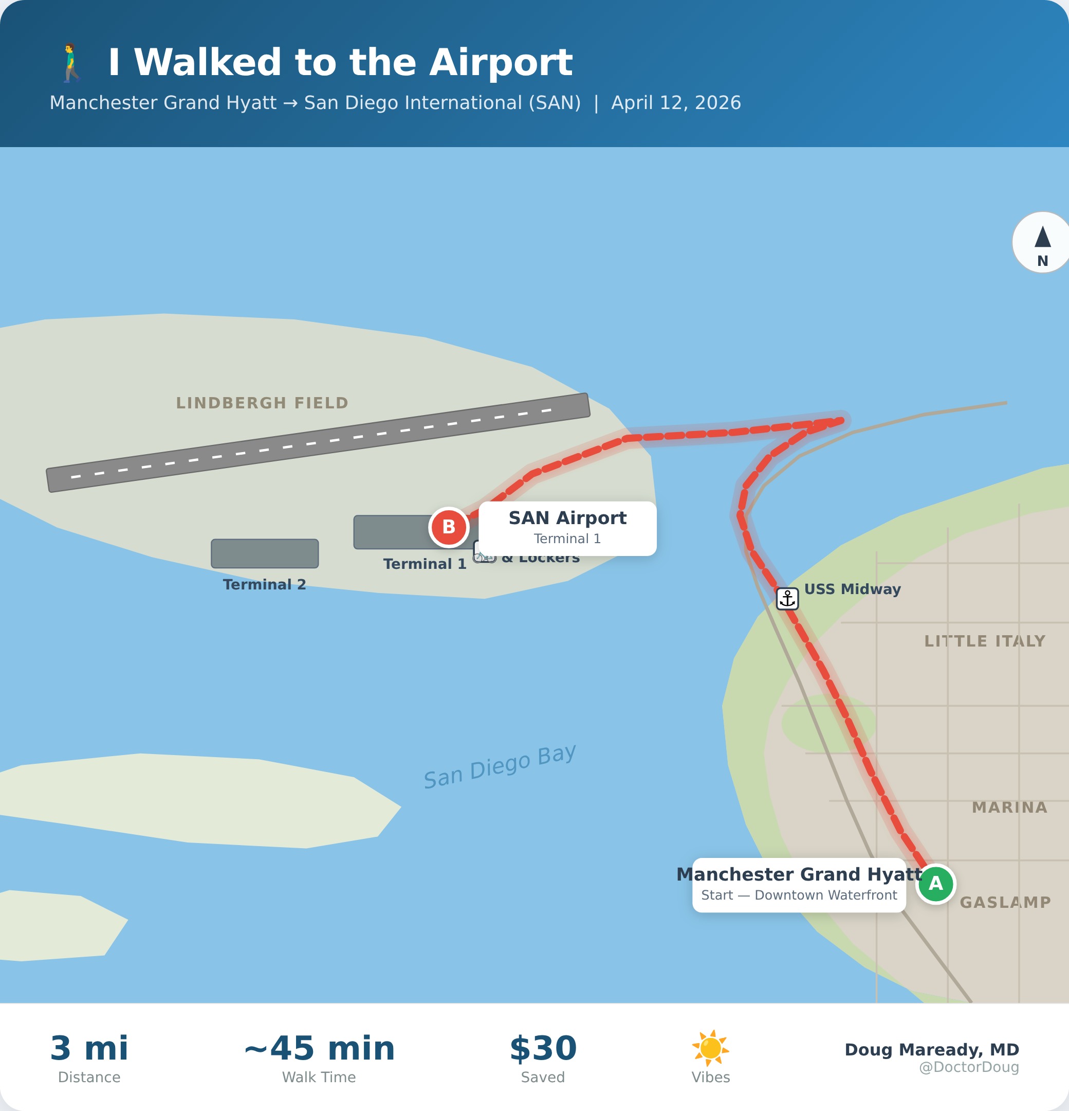
Within ten minutes on foot, can you reach a grocery store, a coffee shop, a school, a park, and a transit stop? If you can hit four out of five, the neighborhood passes mixed-use.

Subtle test: are the storefronts at street level, or behind a parking lot? Storefronts on the street invite stopping in; storefronts across a sea of asphalt do not.

04How does traffic feel?

+

Are cars moving 25 mph or 45 mph? Are there four lanes or two? Do drivers stop at crosswalks unprompted? Stroads — those four-lane semi-highways with strip malls on either side — are the natural enemy of walking.

Heuristic: if you flinch when a car passes, the design failed.

05The "kid on a bike" test

+

Would you let an 11-year-old ride a bike from your front door to the nearest school or library? If yes, the network is genuinely walkable and bikeable. If no, the city is still designed primarily for cars — even if grown adults can manage.

Why this question: the standard for a place to be considered livable is not whether a healthy adult can survive it. It's whether a kid, a grandparent, or a person using a wheelchair can move around with dignity.

Score yourself
5 yeses: you live in a top-tier walkable place — protect it. 3–4: good bones, advocate for the missing pieces. 0–2: your environment is fighting you; build deliberate routines (single great corridor, evening loop, weekend destination) and apply pressure locally.

Adapted from the Walk Score methodology, the Active Living Research walkability framework, and Strong Towns' "stroad vs. street" distinction. Editorial weighting is the author's.